main city choices in maps.
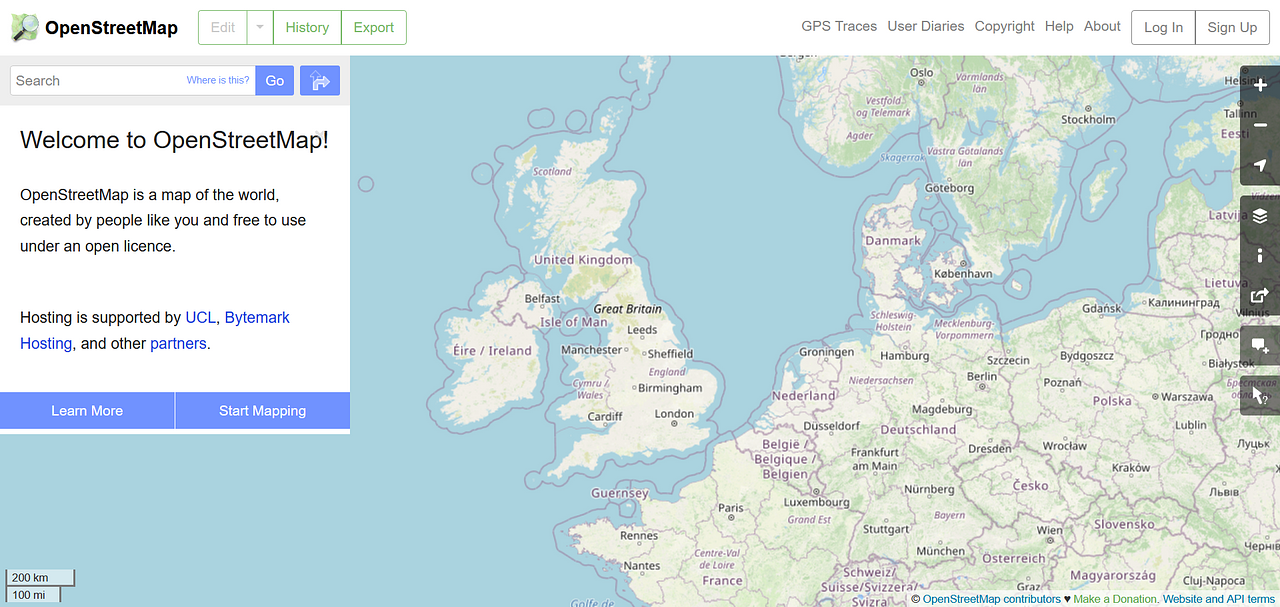
When ever I open a map I consider the logic and impact of which cities are chosen to be displayed. Open map uk chooses London (1st) Birmingham(2nd) and Manchester (7th), the question is why Manchester for a map? Leeds (3rd) Sheffield (4th) and Bradford (5th) would seem more reasonable choices, they are in a similar area of the map and in the case of Leeds as A shorter name more easily defined in position than Manchester. Also if we consider close or associated urban population greater Manchester is 2.6 million while Leeds/Bradford is 2.3 and with the proximity of Sheffield 3 million. Yet Manchester bigger and more vaguely positioned on the map is always used. Why are you not using Leeds? Or even better and more inclusive alternate your northern mapping choice every 6 months/yearly. The north west bias of Manchester (and Liverpool) in the organisation is not helpful to the north of England as a whole.
Stuart Lowe Thu 23 Jul 2020 9:26AM
@jimat37 Do you have a screenshot of what you are talking about? What zoom level are you referring to? Which rendered map? I'm confused because at zoom level 5 I see Leeds, Manchester and Sheffield labelled. At zoom level 6 I see Leeds, Sheffield, Preston, and Liverpool. Obviously the (automatic) renderer has to make choices at different zoom levels..png)
jimat37 Thu 23 Jul 2020 9:35AM
It may well be the choices users of your map are making then?
trigpoint Thu 23 Jul 2020 9:44AM
I am not sure I understand the problem here, assuming you are talking about openstreetmap.org, then London appears at zoom level 4. Leeds, Sheffield, Manchester, Belfast, Birmingham and Cardiff appear at zoom level 5. What is odd is that Edinburgh appears at zoom level 7 after Dundee at zoom level 6.
I am sure that the rendering is based on simple tagging and space to fit in the names but generally importance is about more than simple population, its about other features which will attract people who don't live there. Off the top of my head, and biased towards music I am aware that Manchester and Sheffield have arenas which host large concerts.
I am not really familiar with Leeds and what it has as a draw, I would have been going there for the first time had the AGM taken place.
http://www.ukcities.co.uk/populations/ misses St Asaph and obviously ignores many large towns.
Stuart Lowe Thu 23 Jul 2020 10:01AM
@jimat37 Ahh. You are looking at a specific rendering of the raw map data on some weather app on your phone? Is that correct? If so, I can see where the confusion might come.
The map picture you are looking at is not made by Open Street Map. The underlying map data - not how the data are displayed in that app - comes from Open Street Map. The way all the map data gets turned into an image in your screenshot looks like it is using the Open Map Tiles service (which is a separate thing https://openmaptiles.org/). Open Map Tiles lets people style maps. Whoever made your weather app are the likely the ones who chose how to style the map in their app. That styling will include how place labels are shown at different zoom levels.
Open Street Map's own rendering of the raw data can be found at https://www.openstreetmap.org/ and looks like the screenshots I shared above. My guess, based on what you've shared, is that the "northwest bias" sits with choices of the people who made whatever app it is that you are using. It may not be a deliberate bias on their part but if you want that app to have different labels you will need to approach that app's developers.
Just on a note Jim, OSM isn't "mine" and I'm not involved in any official capacity. OSM is a volunteer-made mapping database collated by thousands of people from around the planet and released under an Open Database Licence so that everyone can use the data without restrictions. I've contributed to the data in the past and I also use the data collated by OSM to make various tools/maps/visualisations in Yorkshire.
Stuart Lowe Thu 23 Jul 2020 10:13AM
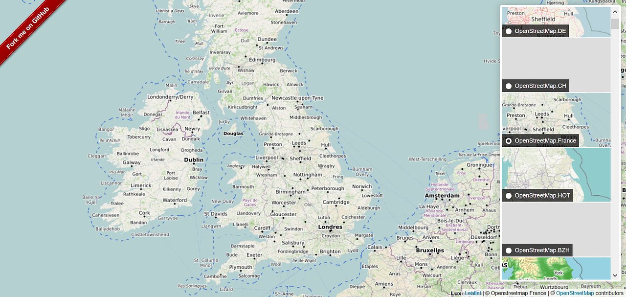
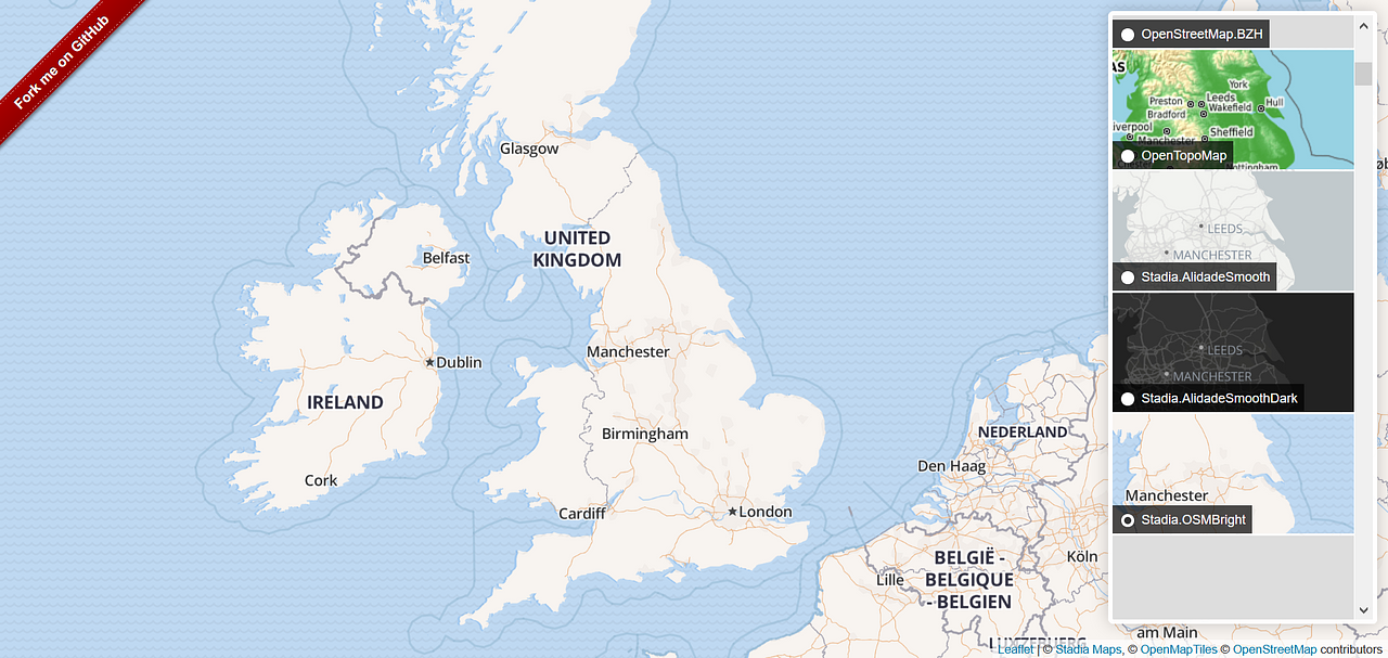
@jimat37 You can find a few examples of how the map data is separate to the rendering-as-an-image at https://leaflet-extras.github.io/leaflet-providers/preview/ Each map here uses the same openly licensed data from Open Street Map but the people/orgs who styled each one made different decisions for how to style the map at different zoom levels. I've attached three screenshots of different renderings. .png)
jimat37 Thu 23 Jul 2020 11:02AM
Many thanks for your comments and information. I appreciate your efforts, maps to me (and probably you) are a thing of beauty and truth. I will take up the issue with the various end user's as obviously openstreetmap are not the issue in terms of equal representation. Once again many thanks for your patience and efforts.
Stuart Lowe Thu 23 Jul 2020 12:19PM
@jimat37 Yep, nothing like a good map :).
By the way, if you ever find anything "wrong" with the underlying data e.g. missing postboxes, wrong shop names, missing cycle paths, wrong speed limits etc then you can help make Open Street Map better by editing it https://openstreetmap.org/.
All the best.
Huw Diprose Fri 24 Jul 2020 4:55PM
If it helps, the "State of the Map 2020" conference just happened.
I saw a talk about how the logic can be written to make sure that "important" names appear well spaced on a map:
https://2020.stateofthemap.org/sessions/3FNPY7/
Probably only of relevance if you get into rendering your own tiles :)
But if you're speaking to other folks about their tiles, might want to ask them how they define the importance of a place name?
One of my takeaways from the talk above is that for Airports and train stations... it's much more nuanced than I'd expected. I've not thought about places... I wonder if you can just get away with population size = importance 🤔
Paul Oldham · Thu 23 Jul 2020 9:02AM
This is just a rendering issue surely. For example our rendering picks Liverpool in preference to Manchester and has Douglas in a bigger font (as it's a capital).
Similarly on https://www.openstreetmap.org it picks Manchester over Liverpool at zoom 5 and Liverpool over Manchester at zoom 6. That will be just choices the renderer is being forced to make based on the space available at each zoom level.